
The Invisible Journey of Rain
My blog, Solidified Air, received an unexpectedly enthusiastic response. Readers remarked that it had drawn attention to something that everyone sees every day but very few consciously notice. Air surrounds us so completely that we almost forget it exists. Yet compressed air becomes steel-cutting power, lifts aircraft into the sky, drives industries, and sustains every breath we take.
The arrival of the first monsoon showers each year evokes a similar feeling. We celebrate the rain and welcome the relief from summer’s relentless heat. Yet very few of us pause to ask an astonishing scientific question. Every year, billions of tonnes of water leave the oceans, travel thousands of kilometres as clouds, and finally descend upon the Indian subcontinent. Why does that enormous mass of water not simply fall back into the sea from which it arose? Why does it remain suspended in the sky throughout its long journey? And what finally persuades it to release itself over land – from Kerala to the Gangetic plains?
The word monsoon itself tells a fascinating story. Derived from the Arabic word mausim, meaning ‘season’, it later came to signify the seasonal reversal of winds observed by Arab sailors navigating the Indian Ocean. For centuries, these predictable changes in wind direction determined the rhythm of maritime trade between Arabia, East Africa, India and Southeast Asia. Long before satellites or weather models existed, navigators understood that the winds themselves possessed a seasonal memory.
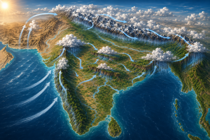
Every summer, the Indian subcontinent undergoes one of the most intense seasonal land-heating events anywhere on Earth. Land responds to solar heating far more rapidly than the oceans. While the vast Indian Ocean warms only gradually because water has an exceptionally high heat capacity, the Indian landmass heats quickly under the tropical sun. During May and June, temperatures across northwestern India and adjoining regions frequently exceed 45°C.
As the land becomes intensely hot, the air above it warms as well. Warm air expands, becomes less dense, and rises, creating a broad region of relatively low atmospheric pressure across much of the subcontinent. Nature abhors imbalance. Air naturally moves from regions of higher pressure to regions of lower pressure in an attempt to restore equilibrium.
South of the equator, over the southern Indian Ocean, relatively cooler and denser air occupies a region of higher pressure. This air begins its long journey northwards towards the low-pressure system over India. Because the Earth rotates continuously, the moving air does not travel in a straight line. Instead, it is deflected by the Coriolis effect. After crossing the Equator into the Northern Hemisphere, the winds are deflected to the right, causing them to curve and eventually approach the Indian subcontinent as the moisture-laden south-westerly winds that define the Indian summer monsoon.
The scale of this transport is almost beyond imagination. Every day during the peak monsoon season, atmospheric rivers carry quantities of water comparable to the discharge of many of the world’s largest rivers combined. Yet almost all this water remains suspended high above the ocean without falling back into it. This is where the real wonder begins.
The clouds that eventually darken the skies over Kerala, Hyderabad, Mumbai, Kolkata, or Delhi are not bags filled with water waiting to burst. Nor are they simply floating masses of liquid water. They are extraordinarily delicate physical systems in which microscopic droplets, ice crystals, water vapour, temperature, pressure and atmospheric motion exist in a state of dynamic balance. Each cloud is a masterpiece of fluid physics.
The first misconception we must set aside is that clouds are collections of large water droplets floating through the sky. If that were true, every cloud would empty itself almost immediately under the pull of gravity.
Instead, a cloud is an astonishingly delicate suspension of unimaginably tiny droplets of water, each typically only about 10 to 20 micrometres in diameter. To appreciate how small that is, consider a human hair. A single strand of hair is roughly 70 micrometres thick. Most cloud droplets are, therefore, only about one-fifth to one-sixth the diameter of a human hair. Millions of them could comfortably fit inside a teaspoon.
Because each droplet is so extraordinarily small, gravity has surprisingly little influence upon it. The downward pull of gravity exists, of course, but the droplet is so light that the resistance offered by the surrounding air almost completely balances its weight. Instead of falling like raindrops, these microscopic droplets behave more like tiny specks of dust floating in a sunbeam. The slightest upward movement of air is sufficient to keep them suspended.
This is the first secret behind the long journey of clouds. They are not carrying rivers through the sky. They are carrying an invisible multitude of microscopic droplets so small that the atmosphere itself can support them. But where do these droplets come from?
Every droplet needs a tiny foundation upon which to form. The atmosphere is never perfectly clean. Floating everywhere are microscopic particles of sea salt, desert dust, pollen grains, industrial aerosols, and so on. These minute particles, known as condensation nuclei, provide the tiny surfaces on which water vapour condenses, allowing droplets to form. They serve as nature’s scaffolding for billions of cloud droplets. But if clouds contain such enormous quantities of water, why do they not gradually become heavier until gravity inevitably wins?
The atmosphere is remarkable for its dynamism. A cloud is an ever-changing physical system. Every second, billions of droplets are formed while billions of others disappear. Water molecules continuously pass between the vapour and liquid states. The cloud that appears unchanged to our eyes is, in reality, undergoing ceaseless renewal.
The journey from the Arabian Sea to Hyderabad, or from the Bay of Bengal to the Himalayas, is, therefore, not undertaken by a fixed collection of water droplets. The cloud is continually rebuilding itself as it travels. The cloud survives because the overall balance remains remarkably stable. This delicate equilibrium can persist for hundreds or even thousands of kilometres. Only when the droplets begin to grow beyond their microscopic size does gravity slowly reclaim its authority.
However, one question still remains: why does so much of this rain fall only after the clouds reach India?
Stretching like a giant wall roughly parallel to India’s western coast stand the Western Ghats. Moist air approaching these mountains has only one option—it must climb. As the air is forced upwards, it expands and cools rapidly. Condensation accelerates. Droplets grow. Clouds thicken. Rain begins.
But the story does not end there. After shedding much of their moisture on the windward slopes, the monsoon winds continue their journey across the Indian peninsula. Here, the great mountain systems of central India—the Satpura and Vindhya ranges, together with the Maikal Hills and the hills of Odisha—act not only as barriers but also as guides and sculptors of the monsoon. Each encounter with rising terrain cools the air anew, triggering fresh condensation and another burst of rainfall. Finally, the Himalayas prevent moist tropical air from escaping into Central Asia and force the remaining moisture to rise, cool, condense, and fall over northern India.
India’s rainfall is a magnificent collaboration between the seas, the winds, and the mountains. The seas, warmed by the Sun’s energy, continuously supply vast quantities of water through evaporation. The monsoon winds carry this invisible water vapour across the subcontinent. When these moisture-laden winds encounter mountain ranges, they are forced to rise, cool, and condense, producing rain. This remarkable partnership gives rise to some of the wettest places on Earth, including Mawsynram and Cherrapunji in the Khasi Hills, while equally nourishing the forests of the Western Ghats, the tea gardens of Agumbe, and countless rivers, fields and villages across the country. What an extraordinary interplay of the seas, the winds, and the mountains! The more we understand, the more extraordinary the ordinary becomes.
MORE FROM THE BLOG

Beyond the Molecule
I recently visited PI Health Sciences Ltd. at Genome Valley, Hyderabad, at the invitation of my long-standing friend, Dr. S. Chandrasekhar, who joined the organisation as Chief Scientific Advisor after his superannuation as Secretary, Department of Science and...
Nataraja: Metallurgy in Motion
Among the great images created by Indian civilisation, few possess the visual authority of the Chola Nataraja. Shiva dances within a circle of flame, one foot planted upon ignorance and the other lifted in liberating grace. His hair flies outward, his arms extend in...

Salt, Spice and Time
Recently, I had the pleasure of attending a family dinner hosted by Vishal Arora, a young CEO and a friend of my son Amol. His wife’s parents were also present. Although they all come from New Delhi, they seemed to carry with them something of the city’s older...
Prof Tiwari, again well put; rain isn’t just water droplets falling from the sky! A product of serious genius in the Creator God! He never stops amazing me. In the Bible, Job tells us that God established the clouds and seas: “He binds up the water in His thick clouds, yet the clouds are not broken under it. He covers the face of His throne, and spreads His cloud over it.” — Job 26:8–9. Of a truth ‘In the beginning GOD’!
Arun bhai, this blog about Rain is a masterpiece. Most people don’t know these facts about rain. You explain them very well in simple language for a common man.
Thank you Sir for sharing yet another wonderful blog!
Reading this made me think about all the processes happening behind the scenes that we rarely notice.This was a nice reminder that even the most familiar parts of nature are the result of countless unseen forces working in harmony. It makes you wonder how many other everyday things we overlook simply because they’ve always been there. Definitely gave me a new appreciation for something I usually take for granted.
Wow, what an absolutely captivating read! Your fluid storytelling and deep reflections on nature turned a scientific explanation of the monsoon into pure magic. I was completely drawn in—air, clouds, winds, and mountains came alive in ways I’d never truly appreciated before. Thank you for making reading not just informative, but genuinely fun and wondrous again. Posts like this remind me why I love diving into blogs like Solidified Air again and again. A new perspective solidifies what one knows loosely. More, please!
Very interesting blog. We were taught in school that the monsoon is one of nature’s most magnificent demonstrations of planetary science in motion. It begins with a simple physical principle—the unequal heating of land and ocean—but unfolds through an intricate choreography of atmospheric pressure, ocean temperatures, winds, moisture, clouds and topography. The Himalayas, the Indian Ocean, the Arabian Sea and the Bay of Bengal all become participants in a vast seasonal circulation that sustains life across the subcontinent. What I learned here is the role of highlands and forests along the way.
From an engineering perspective, the monsoon is a remarkable example of a large-scale, dynamic system driven by energy gradients. Differential heating between the Indian landmass and the surrounding oceans creates pressure differences that set enormous volumes of air in motion. Moisture is transported over thousands of kilometres, lifted by terrain and atmospheric instability, condensed into clouds, and released as rainfall. In effect, solar energy drives a planetary heat engine whose working fluids are air and water.
What makes the monsoon especially interesting to an engineer is its complexity. It is not a simple input-output system but a network of interacting subsystems—oceans, atmosphere, mountains, soil moisture, vegetation and global circulation patterns—each connected through feedback loops. A change in sea-surface temperature, snow cover, wind pattern or land heating can propagate through the system and alter rainfall hundreds or thousands of kilometres away.
It is indeed interesting to know that the monsoon is not a clockwork mechanism. Its behaviour is shaped by phenomena such as El Niño, the Indian Ocean Dipole, snow cover, land temperatures and changing ocean–atmosphere interactions. A small shift in any part of this interconnected system can alter when the rains arrive, where they fall and how intensely they descend.
This is what makes the monsoon both scientifically fascinating and socially profound. It reminds us that climate is not merely weather observed from the sky; it is a living planetary system upon which agriculture, rivers, ecosystems and human livelihoods depend. To understand the monsoon is, in many ways, to understand the delicate intelligence of the Earth itself.
Arunji, Good Morning! You always have a remarkable way of revealing the extraordinary hidden within the ordinary. Just as Solidified Air made us rethink the invisible air around us, this piece transforms the monsoon from a familiar seasonal event into a profound scientific marvel. Looking forward to your blogs every fortnight.
Sir, very well described about the monsoon, its pattern and timings and the water cycle. India is blessed by Almighty God with good monsoon rains, but this year, due to El Niño or Super El Niño, we are so much in deficit almost all over the country and some places are having rains with high intensity, creating flash floods. Now, for the last so many years, we have not been getting evenly distributed, widespread monsoon rains, maybe due to man-made factors. So we need to improve ourselves and our activities to reduce GHGs and environmental temperatures, which may, in turn, improve the monsoon pattern.
Respected Sir, A beautiful piece. What stays with me is that the cloud crosses two thousand kilometres not by gripping its water, but by holding it so lightly the air itself can carry it — endurance through surrender.
And it is never the same cloud that leaves the Arabian Sea and reaches the Ghats; billions of droplets form and vanish each second, the form persisting only through ceaseless renewal. Modern physics here echoes the ancient seers, who saw all things not as fixed but as becoming — the Gita’s prakṛti forever bringing forth and dissolving, yet the order holding. We too are rather like that cloud: not a fixed thing, but a balance that endures only because it never stops remaking itself. Science does not diminish the wonder; it deepens the reverence. Thank you, Sir.
Dear Sir, Greetings! An exceptional piece of writing, Sir. You have beautifully transformed the science of the monsoon into a profound meditation on the harmony that governs nature.
Reading this article reminded me of Lord Krishna’s words in the Bhagavad Gita (9.10): “Under My supervision, material nature brings forth all moving and non-moving beings.” The invisible journey of rain is not merely a scientific phenomenon but a reflection of the divine order that sustains life.
As always, your writing inspires us to look beyond what we see and appreciate the extraordinary intelligence woven into the ordinary. Thank you for another enlightening and deeply inspiring article. Warm Regards.
Very interesting and very nicely described. What a sight to behold: clouds of various shapes and hues. A sight to behold. Go to the hilly regions and walk into and out of the clouds – an experience that cannot be described in words or pictures. No doubt the very sight and smell have inspired many poets and artists. And once it rains …. the brown earth transforms into various shades of green
We have been worshipping Varuna and performing ‘Varuna japam’ for thousands of years. We, as humanity, should preserve this monsoon spirit- it is delicate. As we have seen in the recent past… El Niño, Global warming and all that. Let us preserve this earth for future generations too – it is more satisfying than wealth – it gives bliss and good health. “Sarve Janah sukinaha………………………..Om Shanti Shanti Shantihi”
Rain, like common wonders, should be taught imaginatively in schools. Children should not merely memorise the stages of the water cycle; they should be encouraged to ask why clouds float, how droplets form, why some clouds produce rain while others do not, and why rain sometimes arrives as a drizzle and sometimes as a storm. Science education begins not with answers, but with curiosity. A child who learns to look at rain with wonder may gradually learn to see the entire natural world as a living laboratory. The flame of a fire offers another equally fascinating lesson: a visible meeting of fuel, heat, oxygen, light, colour and chemical transformation. Thank you Sir.
Respected Sir, it’s really an excellent blog. As you so powerfully brought out, rain is one of nature’s most elegant scientific processes. Water rises invisibly from oceans, rivers and soil, travels through the atmosphere as vapour, gathers around microscopic particles to form clouds, and returns to Earth when the droplets become too heavy to remain suspended. Yet rain is more than falling water: it regulates temperature, replenishes rivers and groundwater, renews soil, transports nutrients and sustains almost every form of terrestrial life. What appears to us as a simple shower is, in fact, one movement in the immense planetary circulation of water—a continuous dialogue among the Sun, the atmosphere, the oceans and the living Earth.
This was such a beautiful read. The way you’ve described something as everyday as rain makes it feel almost magical again. I really enjoyed how effortlessly the science blends with that sense of wonder ….it keeps you hooked till the very end. Honestly, after reading this, I’ll probably never look at clouds the same way again
Respected Sir, this piece has profoundly deepened my understanding, unveiling the beautiful physics and natural science that orchestrate the rains. It is a genuine awakening for me. Curiously, the vividness of the description was so immersive that it conjured the anticipation of immediate showers. Yet, despite the thick canopy of clouds stretching across the Lucknow sky, the rain remains an unfulfilled promise, leaving us wrapped in a heavy, humid embrace.
A beautifully written article, Sir. You have transformed the scientific journey of rain into a profound reflection on life, interconnectedness, and humility. It reminds us that every drop carries not just water, but purpose, patience, and renewal. As someone working in agriculture, I deeply appreciate how this invisible journey sustains every seed, every field, and ultimately every civilization. Thank you for inspiring us to look beyond the visible and rediscover the quiet miracles of nature
Prof., Thanks for the good piece on the monsoon rains. Whenever I observe nature’s beauty and the organisation thereof, I am in awe of the grand architect of the flow of nature. Must be a super engineer
I finished reading with a renewed sense of wonder. The monsoon is something we’ve all grown up with, yet I had never paused to ask why clouds don’t simply empty themselves over the ocean. Science here doesn’t diminish the magic; it deepens it. Understanding the invisible journey makes the first raindrop feel even more extraordinary.
This reminded me of your essay on the Arctic tern. Both pieces are about journeys we don’t usually think about. The tern follows an invisible compass, while the clouds follow invisible forces of nature. It’s fascinating how something that seems so ordinary is actually incredibly complex.
Very interesting Blog Prof Tiwari ji. So lucidly it explains the mechanism of the monsoon, physics of cloud suspension and the role of India’s geography. How the western ghats, central highlands, and the himalayas force the air upward, causing it to cool, condense, and precipitate. I thoroughly enjoyed reading it.